Optical or radar imagery can be obtained for an area of interest and used in surveying and mapping, resources, agriculture, disasters, infrastructure and other observation tasks. The programmes and cases below are taken from public materials. They reflect domestic operational practice and are not a list of Global Sight overseas deliveries.
Programmes and cases are taken from the public “Solutions” and “Typical Cases” sections
Solutions
Solutions
Digital agriculture
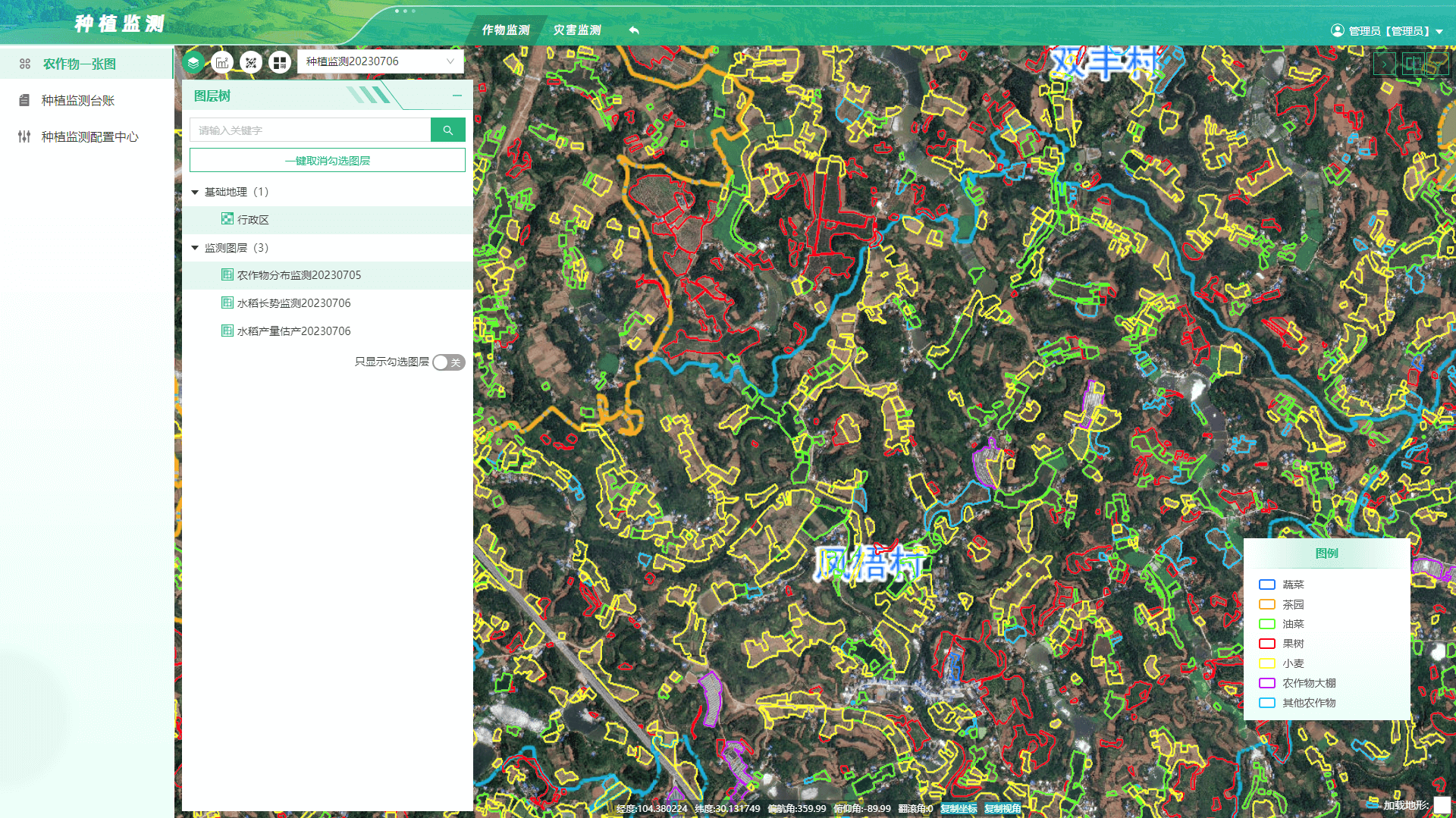
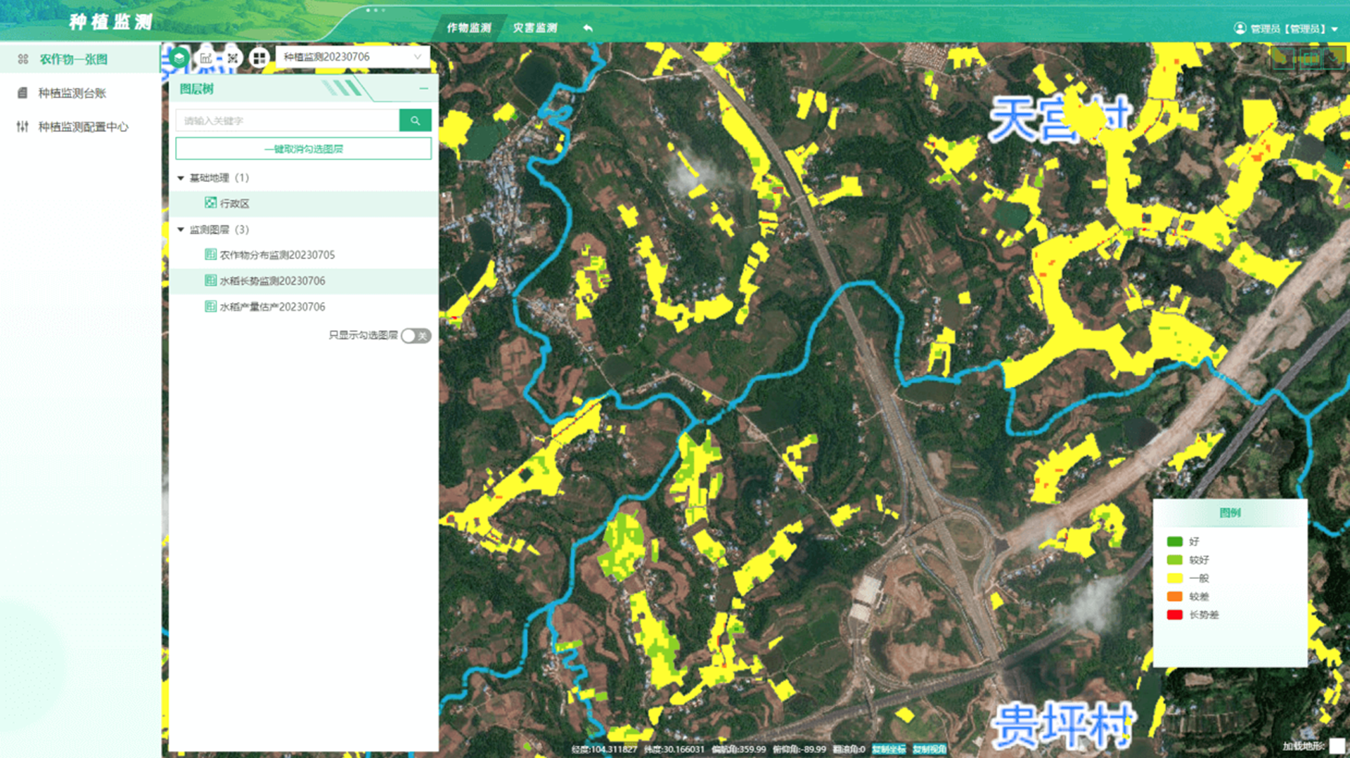
By bringing together agricultural remote sensing, unmanned aircraft, big data, cloud computing, the Internet of Things, artificial intelligence and other modern information technologies and facilities, the programme provides users with agricultural big-data monitoring, analysis and visualisation — including plot management, crop supervision, disaster monitoring, meteorological analysis and environmental monitoring. It supports inventory and supervision of agricultural resources, changes in planting structure, crop-growth management, yield estimation, post-disaster loss assessment, weather warnings and real-time environmental monitoring.
FarmlandFarmland protection
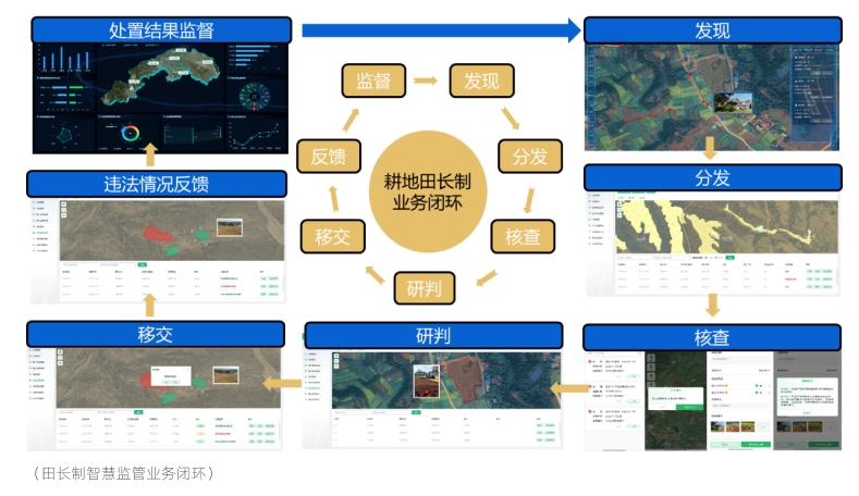
Sub-metre satellite imagery and “AI + remote sensing” are used to carry out a comprehensive “health check” of farmland across a city or county. High-frequency satellite monitoring is used to track grain planting, extract planted area quickly and accurately, hold the farmland red line, and screen plots converted to non-agricultural or non-grain use, as well as abandoned land. A closed loop for handling remotely sensed events is built on the field-chief (Tianzhang) system.
CropsCrop supervision
Satellite remote sensing, meteorology, unmanned aircraft and ground-based IoT are combined to classify planted crops, monitor growth, estimate yields and predict harvest windows. If growth anomalies exceed a threshold, soil moisture, fertility and other information are compared automatically and a report is pushed to the relevant operating entity.
HazardsDisaster monitoring
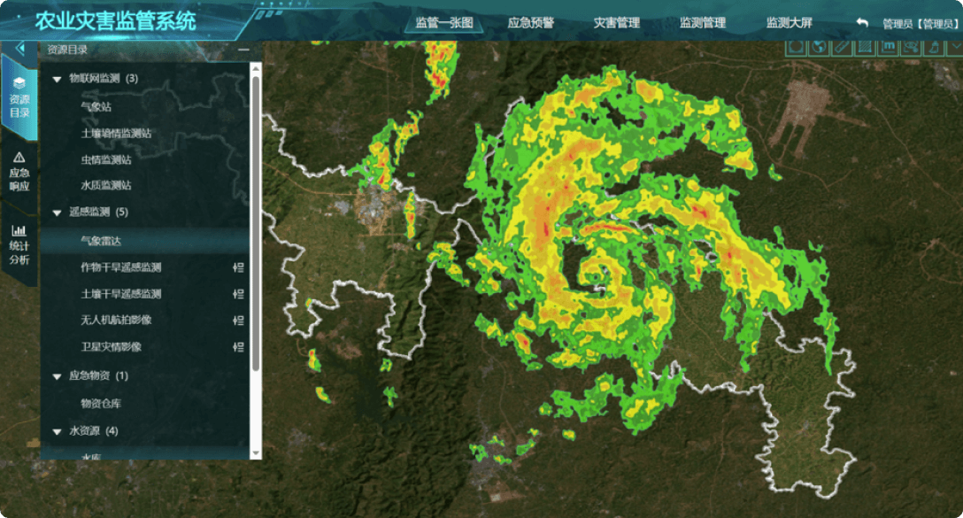
High-frequency satellite observations of crop growth, pests and disease, and natural hazards are combined with meteorological data and applied models to monitor and assess drought, flood, low temperature and other natural disasters, with timely forecasts through the digital agriculture platform.
MachineryFarm-machinery management
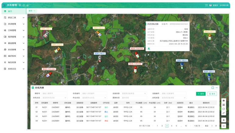
Farm-machinery services use BeiDou plus remote sensing to collect machinery data and operational information, and provide data collection, intelligent supervision, automated handling, statistical analysis and fine-grained management through the digital agriculture platform.
Digital forestry
The space–air–ground digital forestry programme addresses ecological monitoring, resource protection, forest-fire monitoring and forestry carbon-sink monitoring. Supported by remote-sensing satellites, unmanned aircraft and IoT devices, it provides an integrated smart forestry platform for forest management, fire prevention, pest and disease control, and resource protection — “observed from space, checked online and inspected on the ground”.
Forest inventoryForest-resource monitoring
High-resolution imagery and multispectral data are used to monitor forest area, stock volume, canopy cover, tree height, species distribution, forest health and their changes over time.
ProtectionForestry protection and pests
Satellites, unmanned aircraft and ground monitoring are combined to track afforestation progress, forest tending, closed hillside afforestation, natural-forest distribution and pests and disease, and to locate outbreak areas promptly.
Fire & carbonFire prevention and carbon sinks
Satellite and airborne remote sensing, ground video, weather and terrain data are brought together for fire-risk forecasts and fire-point monitoring. Changes in woodland carbon-sink potential are also monitored, supporting carbon-sink management, trading and verification.
Natural-resource supervision
To support national needs such as food security and ecological civilisation, an application system for natural-resource survey and monitoring is built on optical, radar, multispectral and hyperspectral satellite observations, together with an intelligent remote-sensing interpretation platform, providing routine monitoring for satellite resources in natural-resource operations.
Farmland conversionMonitoring of farmland conversion to non-agricultural use
Multi-temporal satellite imagery is combined with third-national-land-survey farmland plots. Automatic change detection identifies changed plots, and land types are confirmed by visual interpretation, helping hold the farmland-protection red line.
Land-use changeLand-use change survey
Using control materials such as the Third National Land Survey base map, and taking the county-level administrative area as the unit, the latest-phase satellite data are used to carry out annual remote-sensing monitoring of land-use change.
Mining & geohazardMining and geological hazards
Satellite remote sensing is used to monitor mine extraction, vegetation recovery and land reclamation. InSAR is used for periodic monitoring of urban surface subsidence and mountain-slope displacement, supporting early identification of geological-hazard risks.
High-resolution imagery of restoration areas is compared across multiple dates to show construction progress and results, supporting land consolidation and the restoration of the geological environment at mines.
Ecological and environmental monitoring
The overall ecological and environmental programme focuses on water, natural ecosystems, soil and low-carbon environmental monitoring. It combines the Internet of Things, big data, satellite remote sensing and intelligent decision-making to establish the status of the ecological environment and its changes over time.
WaterWater-environment monitoring
Multi-source, multi-temporal, multi-resolution satellite data are used for continuous, dynamic monitoring of water bodies, including industrial outfalls, water quality in key lakes and reservoirs, eutrophication, identification of black and odorous water, river flow interruption and oil-spill monitoring.
EcologyNatural-ecosystem monitoring
The programme establishes the status of natural ecological resources and ecological quality, and tracks human activity and its changes in protected areas, supporting ecological-quality assessment, ecosystem classification, supervision of human activity in protected areas, and monitoring of mine extraction.
SoilSoil-environment monitoring
Space–ground methods are used to establish the status of soil resources and to monitor soil moisture, soil erosion and desertification, providing technical support for soil-pollution investigation and remediation.
Low carbonLow-carbon environmental monitoring
Satellite remote sensing and ground-based IoT are combined with operational data on carbon emissions and carbon sinks to build a regional system for emission, sink and carbon-assessment monitoring, with customised services for government and enterprise.
Natural-disaster monitoring and early warning
Operational disaster data are fused with space–air–ground observations to extract information on earthquakes, geological hazards (landslides, debris flows and others), flood and drought, forest fire, meteorological disasters and secondary and derivative events. Multi-hazard warning, risk-assessment and loss-assessment models support hazard screening, emergency monitoring, post-event verification and comprehensive management.
Multi-hazardMulti-hazard and disaster-chain monitoring and warning
Risks, exposure and historical disaster data are combined with big-data analysis and artificial intelligence. Disaster-forecast models are used to project developments and analyse secondary and derivative hazards.
AlertsRelease of warning information
On the basis of a comprehensive assessment and emergency plans, warning and assessment information is generated automatically and pushed in a targeted way to responsible persons, the public and government departments by SMS, WeChat, email and other channels.
ResponseEmergency monitoring and situation tracking
Multi-source satellite data are used for dynamic monitoring of forest fires, floods, sudden geological hazards and similar events, producing situation assessments and rescue-route planning.
AssessmentVerification, loss assessment and comprehensive management
Historical and current remote sensing and field surveys are combined to determine the affected area and damage, continue monitoring post-disaster reconstruction, and assemble a comprehensive natural-disaster monitoring map.
Typical Cases
Typical cases (domestic projects)
The three projects below are domestic cases from public materials. They are not Global Sight overseas delivery cases.
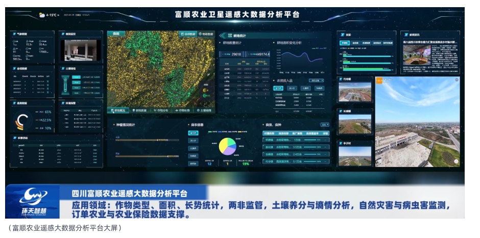
To implement the 2022 Key Points for Digital Rural Development and the plan for the Fushun County national rice-and-sorghum agricultural park, Huantian Wisdom drew on its own Huantian Constellation to introduce a “satellite + blockchain” application model and build the Fushun Agricultural Satellite Remote-Sensing Big Data Service Platform. The aim is to support green, high-quality development of Fushun’s rice, sorghum and citrus industries, and to improve quality and efficiency at the Miaoxian Lake provincial modern agricultural park in Fushun County.
Huantian Constellation remote sensing is used to extract farmland-plot information efficiently and to supervise planting conditions — including growth and pests and disease — for rice, sorghum and citrus across Fushun’s thirteen townships. Combined with weather and historical yield data, this supports accurate yield estimation. Ground-based IoT sensors provide fine-grained online monitoring of soil nutrients and moisture. Blockchain is applied to data analysis across agricultural production, circulation and trade.
Fushun agricultural remote-sensing big-data project (source: public typical cases)
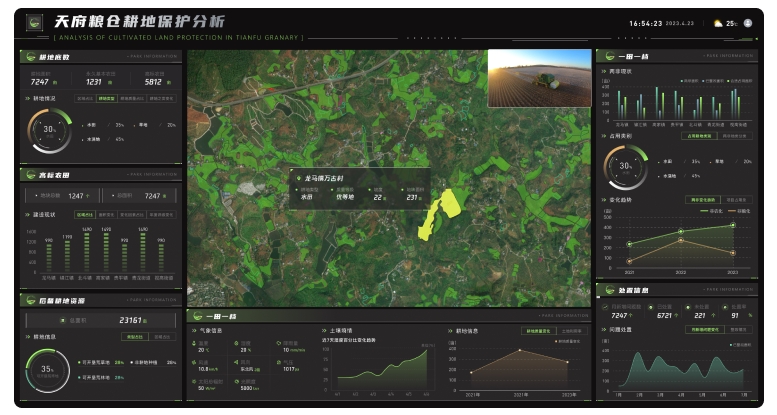
Digital Tianfu Granary project
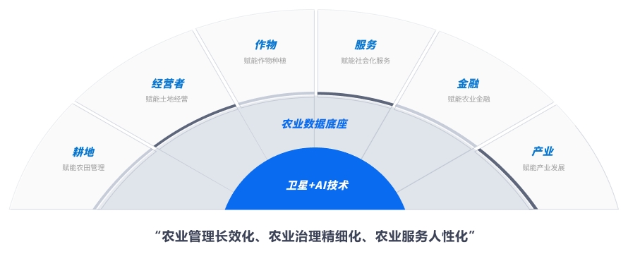
In response to the policy call to hold the farmland red line and protect the Chengdu Plain as a grain-producing heartland, Huantian Wisdom used imagery from its own Huantian Constellation to build an agricultural big-data foundation. The project supports five operational cores — farmland, operators, crops, finance and services — and promotes lasting agricultural management, finer-grained governance and more people-centred agricultural services.
1. High-frequency satellite monitoring of grain planting is used to extract planted area quickly and accurately, and to detect and stop conversion of farmland to non-grain or non-agricultural use.
2. A space–air–ground sensing system monitors grain crops dynamically through the full phenological cycle, analyses seedling condition and growth, and estimates grain yield.
3. Disaster prevention, mitigation, warning and assessment: satellite imagery is combined with meteorological data to monitor and assess drought, flood, low temperature and pest and disease risk.
4. Farm-machinery management: BeiDou plus remote sensing is used to collect machinery and operational information for real-time monitoring, operational analysis, dispatch and subsidy management.
5. Agricultural financial services: satellite, unmanned-aircraft, ground and meteorological sources are combined with rural land-management-rights transfer data to form a file for each field, supporting underwriting for policy insurance, post-loan agricultural supervision and loss verification.
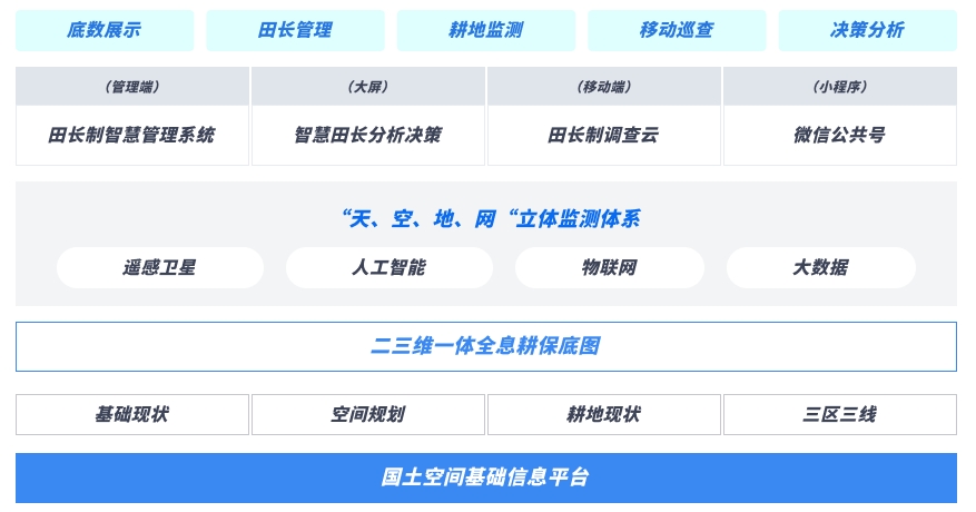
Under a unified plan and organisation, and in line with ministry and provincial requirements for informatisation, Huantian Wisdom built a smart management system for the Meishan field-chief (Tianzhang) programme. Digital governance is used to strengthen farmland protection, with a clear baseline, strict protection, fine-grained management, intelligent supervision and evidence-based decision-making.
The system sits on a territorial-space information platform and brings together baseline conditions, spatial plans, the current status of farmland, and the “three zones and three lines”. It builds a holographic farmland-protection base map in two and three dimensions. AI remote sensing, the Internet of Things and big data are used to create a “space, air, ground and network” monitoring system. Through a management terminal, an analysis and decision dashboard, a survey-cloud mobile terminal and a WeChat official account, the platform supports baseline display, field-chief management, farmland monitoring, mobile inspection and decision analysis, so that farmland protection can be “detected early, warned early and handled early”.